Shenzhen Metro Subway Map 深圳地铁2.1
Publisher Description


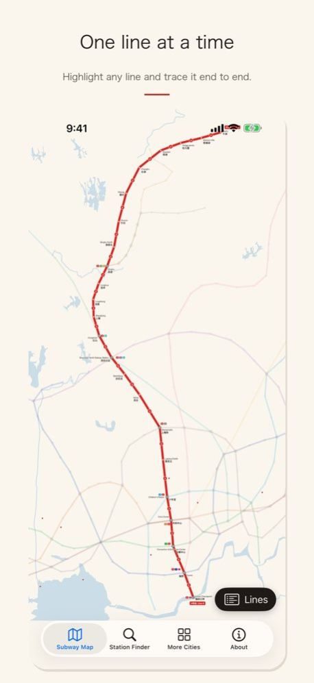
Shenzhen's metro, drawn as a map you'll want to keep. Whale's Shenzhen Metro puts the whole Shenzhen Metro - 19 lines and 380 stations, everything open in 2026 - on a paper-and-ink map made for this app, with every station named in English, Chinese and pinyin. Works offline. Free.
THE MAP
Cream paper, ink lettering, a touch of vermilion: a map that reads like the city instead of a diagram. Every line in its official colour, with its number repeated along the line so you never lose track of which one you're on. Interchanges carry badges for every line that stops there, each terminus is named, and the rivers, lakes and shoreline are drawn in. Window of the World, Shenzhen Bay Park, Lianhuashan Park, Huaqiangbei and Dongmen are marked where they really are. It's drawn as vectors, so pinch in as far as you like - it stays crisp.
FIND A STATION
. Type any station in English, Chinese or pinyin - "Civic Center", "市民中心" or the first few letters all work
. The whale flies you there and points at it
. Your recent stations are remembered
PLAN A ROUTE
. Tap a station, then another: the fewest-stops route is drawn bold with everything else dimmed
. Transfers and a journey-time estimate on the card - Shenzhen North to Window of the World, for example
. Share the route as text to a friend, or to your notes
READ THE SIGNS
. Every station card shows the Chinese name, pinyin with tone marks, and English
. Tap the speaker to hear the name spoken aloud
. Highlight a single line to trace it from end to end
MADE FOR TRAVEL
. Fully offline: no roaming, no VPN, no account, nothing to download after install
. Day or night: the paper map, or ink on slate - your choice in About
. iPhone and iPad
. Free, supported by one small banner
WHAT'S ON THE MAP
Lines 11 and 20 to Bao'an Airport, the Line 2/8 through-service to Xiaomeisha, Lines 12, 13, 14 and 16, the Longhua trams, the Pingshan Sky Shuttle, and the Hong Kong border crossings at Luohu, Futian Checkpoint and Shenzhen Bay. 76 interchange stations, all with badges.
GOOD TO KNOW
Is it up to date? Yes - 19 lines and 380 stations as of 2026, including this year's openings. Station positions come from OpenStreetMap; the design and layout are ours.
Learning Chinese? Every station card links to HSK Hero, our recognition game for the 5,000 HSK words - the same studio, the same care.
Going to other cities? Whale's Metro Maps cover Beijing, Chengdu, Chongqing, Guangzhou, Hangzhou, Hong Kong, Nanjing, Shenzhen, Suzhou, Tianjin, Wuhan, Xi'an and Zhengzhou. The More Cities tab links to each.
Who makes it? Handtechnics, a small independent studio that has been making Chinese travel and learning apps since 2012.
Download it before you land. 一路平安!
Version History Routes now mark both ends of the journey: a start pennant on the first station and a finish flag on the last. Station and line names are no longer cut off at larger text sizes. Plus a number of small fixes throughout. 2.1 Sep 24 Completely rebuilt for 2026. A brand-new map with every line and station current for this year, drawn in a paper-and-ink style you can read at a glance. Tap any station for its name in Chinese, pinyin and English — and hear it spoken. Plan a route between any two stations. Highlight a single line. Night mode. Full iPad support. Whale's Metro Maps — by Handtechnics. 2.0 Sep 7 - minor user interface update; miscellaneous 1.2 12/03/2019 Updated for iOS 11. 1.1 10/30/2017 1.0 12/05/2016
About Shenzhen Metro Subway Map 深圳地铁
The company that develops Shenzhen Metro Subway Map 深圳地铁 is Handtechnics. The latest version released by its developer is 2.1.
To install Shenzhen Metro Subway Map 深圳地铁 on your iOS device, just click the green Continue To App button above to start the installation process. The app is listed on our website since 2026-10-15 and was downloaded 5 times. We have already checked if the download link is safe, however for your own protection we recommend that you scan the downloaded app with your antivirus. Your antivirus may detect the Shenzhen Metro Subway Map 深圳地铁 as malware if the download link is broken.
How to install Shenzhen Metro Subway Map 深圳地铁 on your iOS device:
- Click on the Continue To App button on our website. This will redirect you to the App Store.
- Once the Shenzhen Metro Subway Map 深圳地铁 is shown in the iTunes listing of your iOS device, you can start its download and installation. Tap on the GET button to the right of the app to start downloading it.
- If you are not logged-in the iOS appstore app, you'll be prompted for your your Apple ID and/or password.
- After Shenzhen Metro Subway Map 深圳地铁 is downloaded, you'll see an INSTALL button to the right. Tap on it to start the actual installation of the iOS app.
- Once installation is finished you can tap on the OPEN button to start it. Its icon will also be added to your device home screen.
Program Details
System requirements
Download information
Pricing
Version History
version 2.1
posted on 2026-10-15
Version History Routes now mark both ends of the journey: a start pennant on the first station and a finish flag on the last. Station and line names are no longer cut off at larger text sizes. Plus a number of small fixes throughout. 2.1 Sep 24 Completely rebuilt for 2026. A brand-new map with every line and station current for this year, drawn in a paper-and-ink style you can read at a glance. Tap any station for its name in Chinese, pinyin and English — and hear it spoken. Plan a route between any two stations. Highlight a single line. Night mode. Full iPad support. Whale's Metro Maps — by Handtechnics. 2.0 Sep 7 - minor user interface update; miscellaneous 1.2 12/03/2019 Updated for iOS 11. 1.1 10/30/2017 1.0 12/05/2016
version 2.1
posted on 2026-09-24
Version History Routes now mark both ends of the journey: a start pennant on the first station and a finish flag on the last. Station and line names are no longer cut off at larger text sizes. Plus a number of small fixes throughout. 2.1 4h ago Completely rebuilt for 2026. A brand-new map with every line and station current for this year, drawn in a paper-and-ink style you can read at a glance. Tap any station for its name in Chinese, pinyin and English — and hear it spoken. Plan a route between any two stations. Highlight a single line. Night mode. Full iPad support. Whale's Metro Maps — by Handtechnics. 2.0 Sep 7 - minor user interface update; miscellaneous 1.2 12/03/2019 Updated for iOS 11. 1.1 10/30/2017 1.0 12/05/2016
version 2.0
posted on 2026-09-17
Version History Completely rebuilt for 2026. A brand-new map with every line and station current for this year, drawn in a paper-and-ink style you can read at a glance. Tap any station for its name in Chinese, pinyin and English — and hear it spoken. Plan a route between any two stations. Highlight a single line. Night mode. Full iPad support. Whale's Metro Maps — by Handtechnics. 2.0 Sep 7 - minor user interface update; miscellaneous 1.2 12/03/2019 Updated for iOS 11. 1.1 10/30/2017 1.0 12/05/2016
version 2.0
posted on 2026-09-10
Version History Completely rebuilt for 2026. A brand-new map with every line and station current for this year, drawn in a paper-and-ink style you can read at a glance. Tap any station for its name in Chinese, pinyin and English — and hear it spoken. Plan a route between any two stations. Highlight a single line. Night mode. Full iPad support. Whale's Metro Maps — by Handtechnics. 2.0 2d ago - minor user interface update; miscellaneous 1.2 12/03/2019 Updated for iOS 11. 1.1 10/30/2017 1.0 12/05/2016
version 1.2
posted on 2019-12-03
3 Dec 2019 Version 1.2
- minor user interface update; miscellaneous
version 1.2
posted on 2019-12-03
Dec 3, 2019 Version 1.2
- minor user interface update; miscellaneous
version 1.0
posted on 2016-12-05
version 1.2
posted on 1970-01-01
2019年12月3日 Version 1.2
- minor user interface update; miscellaneous
